Creating a 'holiday map' in Google Maps
I recently read a book where one of the characters loved travelling. Each time he was able to spare some money (and vacation days), he travelled to a country where he never had been before.
He had a big map of the world on his living room wall, and whenever he returned from a vacation, he marked the spot on the map with a needle.
When I read this, my first thought was: “hey, I could probably do this with Google Maps”…so I did.
Implementation
After reading the Google Maps API docs first, I found this example on Stack Overflow, which is already pretty close to what I wanted to do.
I only made a few small changes, and came up with this in the end:
<!DOCTYPE html>
<html>
<head>
<meta http-equiv="content-type" content="text/html; charset=UTF-8" />
<title>Holiday Map</title>
<script src="http://maps.google.com/maps/api/js?sensor=false"
      type="text/javascript"></script>
<style type="text/css">
.gm-style-iw {
width: 350px;
min-height: 60px;
}
</style>
</head>
<body>
<div id="map" style="height: 800px; width: 100%;"></div>

<script src="holidays.js"></script>
<script type="text/javascript">
var map = new google.maps.Map(document.getElementById('map'), {
  zoom: 3,
  center: new google.maps.LatLng(50.906843, 6.666629),
  mapTypeId: google.maps.MapTypeId.ROADMAP
});

var infowindow = new google.maps.InfoWindow();
var marker, i;

for (i = 0; i < locations.length; i++) {
  marker = new google.maps.Marker({
    position: new google.maps.LatLng(locations[i][0], locations[i][1]),
    map: map,
    icon: 'holidaymap-marker' + locations[i][2] + '.png'
  });

  google.maps.event.addListener(marker, 'click', (function(marker, i) {
    return function() {
      infowindow.setContent(locations[i][3] + '<br>' + locations[i][4]);
      infowindow.open(map, marker);
    }
  })(marker, i));
}
</script>
</body>
</html>
Note: This code works with version 3.x of the Google Maps API, which is the current version at the time I’m writing this.
Changes
Most of the changes were only small cosmetical things:
- increased the size of the
divthat holds the map (100% screen width) - increased the size of the
InfoWindowwhich opens when you click on one of the markers
The only thing worth mentioning is the file holidays.js.
Its content originally was inside the JavaScript code in the HTML file…but this is the part that will be edited the most in the future, so I extracted it into a separate file:
var locations = [
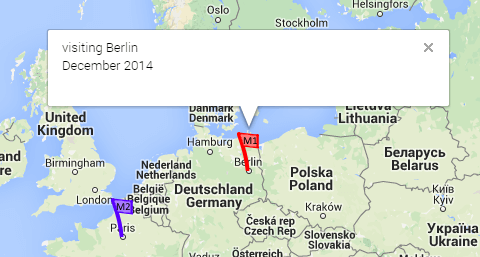
[52.516441, 13.377693, 1, 'visiting Berlin', 'December 2014'],
[48.858374, 2.294481, 2, 'summer vacation in Paris', 'June 2014'],
];
You probably noticed that each line has three additional properties beside the GPS coordinates.
Custom markers
The single number directly behind the coordinates (1 and 2 in this example) is used to show different marker icons.
I need this because I wanted to use different markers for places I visited alone, and places I visited together with my wife.
I’m setting the icon of the markers to 'holidaymap-marker' + locations[i][2] + '.png' in the HTML file.
So the files for the icons need to be named holidaymap-marker1.png, holidaymap-marker2.png and so on.
In this example, I will use these images:


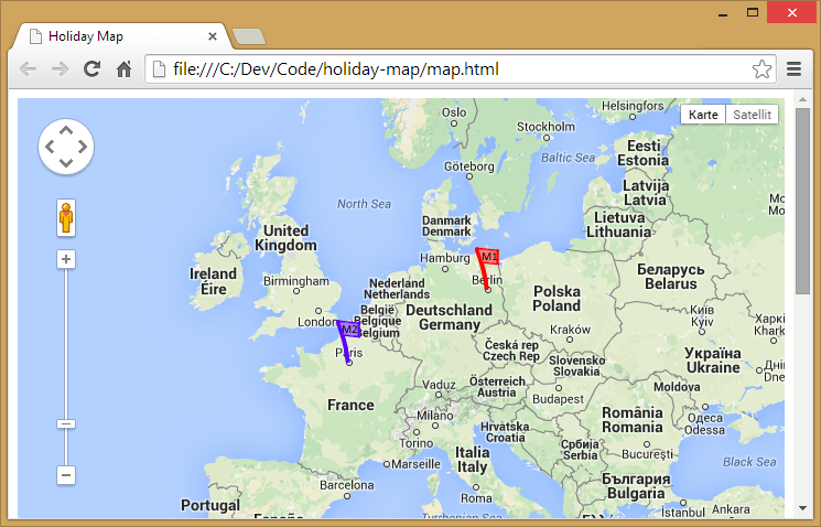
With the example data from above, the finished map with custom markers will look like this:
The InfoWindow
The last two properties (for example, visiting Berlin and December 2014 in the first line of holidays.js) will be shown in the InfoWindow which pops up when you click on a marker: